Forest fires have long posed a significant challenge in Uttarakhand, where the combination of dry conditions, soaring temperatures, and human activity often leads to both major and minor wildfires. While large-scale fires dominate headlines due to their destructive impact on the ecosystem and communities, smaller fires, which often go undetected, can spread rapidly and escalate into serious threats. In recent years, the state has witnessed numerous such incidents, underscoring the need for a robust fire detection and management system.
Recognizing the urgency to address this problem, IFS Dharm Singh Meena, now posted as the Conservator of Forests, Bhagirathi Circle, took proactive measures to develop a cutting-edge forest fire detection system. Leveraging satellite-based technology, Mr. Meena and his team have not only improved early detection but also drastically enhanced the response capabilities of the forest department.
Identifying the Need for Precision
In 2015-16, Dharm Singh Meena was posted in the Information Technology and Geomatics Center of the Forest Department. During this period, he recognized significant gaps in how forest fires were being monitored. At the time, India relied on NASA’s MODIS (Moderate Resolution Imaging Spectroradiometer) satellites, which offered a resolution of 1,000 square meters. While useful for detecting large fires, this system missed smaller fires that could spread if not addressed in time.
“Back then, we could only detect fires that spanned at least one square kilometer,” Mr. Meena shared with Indian Masterminds. “The system worked but wasn’t capable of identifying smaller fires quickly enough. I saw an opportunity to create a more precise system, one that could detect even minor fires and allow us to respond much faster.
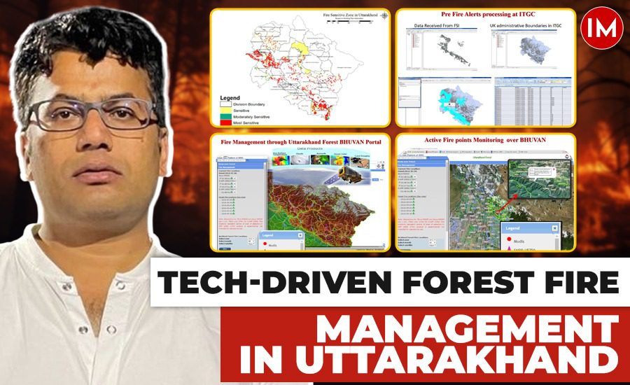
“To fill this gap, he initiated the development of an advanced detection system in collaboration with the National Remote Sensing Center (NRSC) in Hyderabad. His goal was to create a comprehensive decision-support system for the Forest Department, integrating modules for forest fire management, human resource management, and vehicle tracking, all under the Uttarakhand Forest Bhuvan portal.
Integrating NASA’s Technology
To enhance the precision of the new system, Mr. Meena worked with international partners, including NASA, under a tripartite agreement involving the NRSC and other space agencies. “We integrated NASA’s SNPP VIRS (Suomi National Polar-Orbiting Partnership Visible Infrared Imaging Radiometer Suite), which has a resolution of 375 to 750 square meters. This allowed us to detect even smaller fires with far greater accuracy,” Mr. Meena said.
The system also mapped India’s forest boundaries, including division and beat maps, enabling more precise fire location tracking. Fires were displayed on the Bhuvan portal, and alerts were sent to forest officials via SMS, down to the guard level.
Faster Detection, Quicker Response
This increased resolution allowed the Forest Department to detect smaller fires that were previously overlooked. Mr. Meena further clarified that earlier, only large-scale fires were visible, so the number of incidents seemed lower. But with this system, even the smaller fires are detected, which naturally increases the fire count. It’s not that there are more fires now—just that we can see what we missed before.
This improvement in detection has led to more efficient resource allocation. Forest guards, who are often responsible for monitoring vast areas, now receive real-time alerts, enabling them to act swiftly. “A guard might be overseeing an area of 20,000 hectares, but with real-time data they can respond much faster to emerging fires and prevent them from growing,” he said.
Implementation and Awareness Challenges
Though the technology itself was revolutionary, its implementation required substantial effort, particularly in training forest officers and raising public awareness. Initially, the system required manual updates, but over time, automatic data dissemination was integrated to streamline the process.
However, the biggest challenge lay in raising awareness about man-made fires. “Almost all forest fires in Uttarakhand are caused by human activity. Despite our technological advances, without public cooperation, it’s very difficult to prevent these fires. We run year-round awareness programs to educate the community about fire prevention,” he explained.
The Push for Modern Equipment
While technological advancements have significantly improved fire detection, Mr. Meena highlighted the need for better firefighting equipment on the ground. “In India, most forest fires are surface fires. Unlike other countries, where they face crown fires and need large-scale chemical use, we still rely on basic fire-beating techniques.” To address these gaps, Mr. Meena and his team are working to improve both the equipment used by forest guards and the infrastructure for fire prevention. In a further effort to streamline fire management, the forest department has recently launched a mobile app designed to work alongside their existing systems. The app automatically processes satellite detection data and sends real-time alerts to forest officials. It also allows them to report fires directly, including uploading photos, which speeds up response times.
“With the app, guards receive instant alerts about fires in their area, allowing them to respond quickly and communicate efficiently with their teams. It’s a major step forward in making our system more effective,” Mr. Meena added.
Moving Forward
IFS officer Dharm Singh Meena’s innovations have fundamentally transformed how Uttarakhand manages its forest fires. By integrating advanced satellite technology and developing in-house solutions like the Bhuvan portal, fire detection has become faster and more accurate. However, as Meena himself points out, challenges remain.
“We’ve come a long way with technology, but there’s still more to do on the ground,” he said.Now posted as the Conservator of Forests, Bhagirathi Circle, the officer remains committed to further improving India’s forest fire management capabilities.

