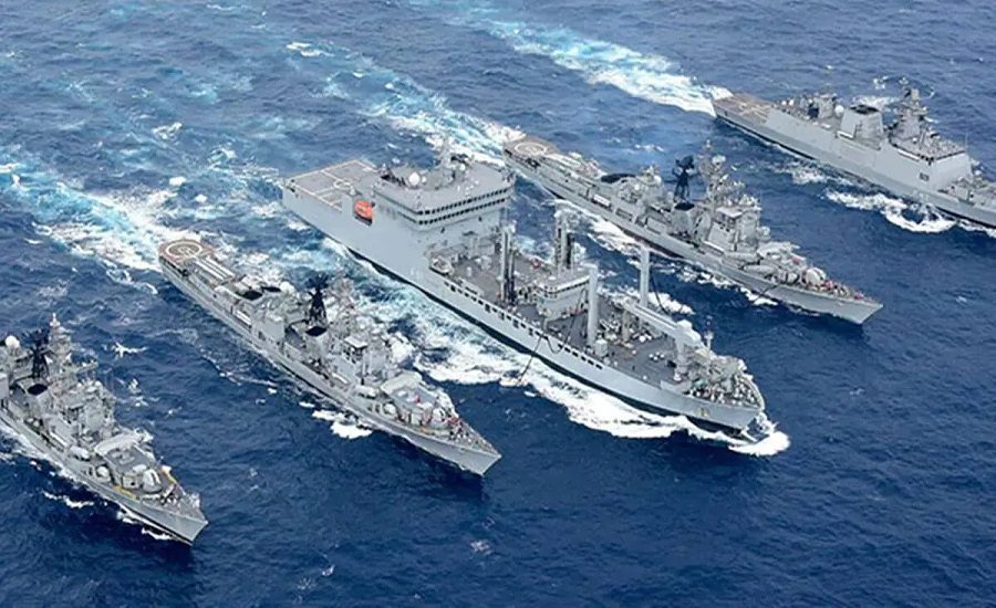
India and Mauritius have deepened their maritime ties with the successful completion of the 18th joint hydrographic survey by the Indian Navy’s survey ship INS Sutlej.
The mission covered an extensive area of approximately 35,000 square nautical miles around Mauritius, supporting marine charting, coastal regulation and longer-term resource management.
It was conducted in close coordination with national agencies of both countries under the existing Memorandum of Understanding (MoU) on hydrography between India and Mauritius.
Key feature of this 18th joint hydrographic survey mission
Six personnel from various ministries in Mauritius embarked on the INS Sutlej for hands-on training in modern hydrographic surveying techniques.
In addition to charting and mapping work, the mission included joint EEZ (Exclusive Economic Zone) surveillance and anti-piracy patrols executed together with the Mauritius National Coast Guard — enhancing regional maritime security.
At a formal ceremony onboard, the survey “fair-sheet” was handed over to Mauritian authorities in the presence of Hon’ble Mr. Shakeel Ahmed Yousuf Abdul Razack Mohamed (Minister of Housing & Lands, Mauritius) and Anurag Srivastava (High Commissioner of India to Mauritius).
Background & Importance 18th joint Hydrographic Survey Mission
Hydrographic surveys are key to:
- Producing accurate navigational charts and electronic navigation systems, ensuring safe shipping lanes.
- Assisting coastal regulation, underwater terrain mapping, resource management (such as seabed minerals and fishing zones) and environmental planning.
- By mapping the seabed and monitoring the EEZ, nations can better protect against threats such as piracy or unregulated exploitation.
Why Mauritius?
Mauritius, located strategically in the Indian Ocean Region (IOR), is a key partner for India’s maritime strategy. Working together strengthens India–Mauritius maritime cooperation and supports the Indo-Pacific vision of regional security and growth.
This 18th joint mission reaffirms the long-standing ties between the two nations, aligned with India’s “MAHASAGAR – Mutual and Holistic Advancement for Security and Growth Across the Regions” framework.
The Vessel: INS Sutlej – Profile & Capabilities
INS Sutlej is a specialised hydrographic survey ship of the Indian Navy, built by Goa Shipyard Limited and commissioned on 19 February 1993.
Key technical features of INS Sutlej & roles
- INS Sutlej is equipped with multi-beam swath echo sounder, side-scan sonar, differential GPS, motion sensors, sea gravimeter, magnetometer and automated data-logging systems — enabling high-precision seabed mapping and real-time digital survey processing.
- The vessel is also part of the Sandhayak-class survey ships and serves under the Southern Naval Command of India.
- Over its service life, INS Sutlej has completed numerous hydrographic missions both domestically and overseas, including work off Tanzania, Seychelles, Maldives, Myanmar, Andaman & Nicobar Islands and Gujarat/Goa.
Strategic Outcomes & Future Implications
For India and Mauritius:
- Enhanced maritime charting of Mauritius’s waters means safer navigation, improved port access and stronger maritime infrastructure — aiding Mauritius’s Blue Economy ambitions.
- Training of Mauritian personnel strengthens capacity-building in hydrography within the island nation, building local expertise in marine mapping and resource management.
- Joint EEZ surveillance and anti-piracy patrols bolster regional maritime security in the Indian Ocean, benefitting both nations and contributing to stability in the region.
For India’s maritime diplomacy:
- The mission underscores India’s intent to be a “preferred partner” in the IOR, deepening cooperation with island states and littoral nations.
- It fits in broadly with India’s SAGAR (Security and Growth for All in the Region) vision and demonstrates India’s ability to deploy specialised vessels for overseas capacity-building and mapping missions.
- Continued execution of such missions builds India’s soft-power and strategic influence in the Indian Ocean, especially as maritime competition rises.