People often wonder why students who pursue B.Tech or M.Tech degrees in fields like computer science, aerospace, or other branches of engineering later shift their focus to preparing for the UPSC exams to become IAS or IPS officers. Wouldn’t it make more sense for them to continue contributing to engineering and science – fields where their technical expertise could directly benefit the country?
Some even argue that civil services are better suited for those from humanities or social science backgrounds. But every so often, a story comes along that challenges this assumption – and proves how powerful a blend of technology and governance can be.
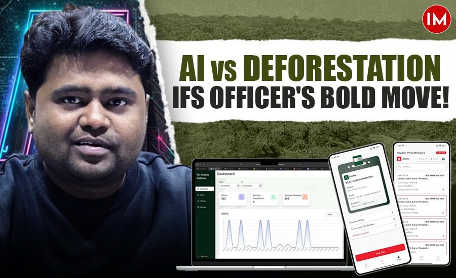
Meet Akshay Rathore, a 2016-batch Indian Forest Service (IFS) officer from the Madhya Pradesh cadre. With a B.Tech degree from IIT Roorkee, he has managed to create a unique bridge between high-end technology and forest conservation.
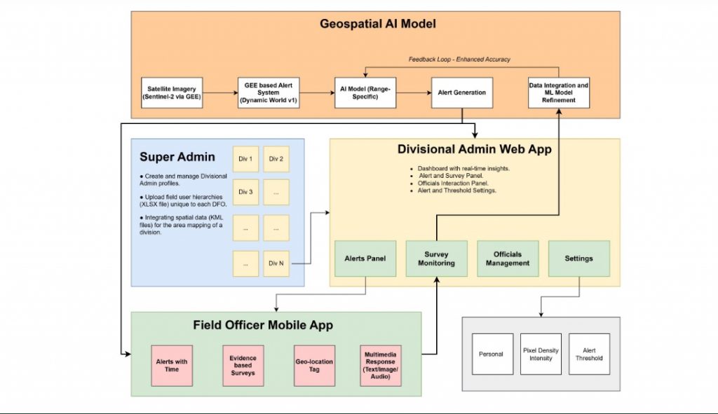
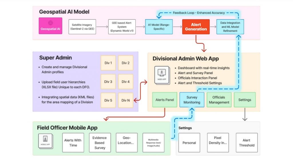
He developed an Artificial Intelligence (AI)-based machine learning model that uses satellite imagery to monitor forest health and detect early signs of deforestation. This innovative tool is now being actively used by the Forest Department in Guna, Madhya Pradesh, to combat deforestation and address a range of environmental challenges.
What makes Mr Rathore’s achievement even more remarkable is that he worked on the project almost entirely on his own. Over the span of five months, he planned, designed, and coded the model himself – relying heavily on his engineering background. Initially tested informally, the model showed consistent accuracy above 50%. Encouraged by these results, he officially implemented it as part of Guna’s forest management strategy.
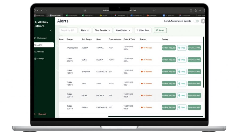
In an exclusive conversation with Indian Masterminds, Mr Rathore, currently the Divisional Forest Officer (DFO) of Guna, explained how the model functions, the kind of data it processes, and how it’s transforming the department’s approach to conservation. By introducing a data-driven, tech-enabled method to track and prevent deforestation, he is helping reshape how forest governance can be done in India.

ECO MONITORING GOES STATEWIDE
For the past month, Mr Rathore’s AI-based model has been officially implemented across five ecologically sensitive districts in Madhya Pradesh – Guna, Shivpuri, Burhanpur, Khandwa, and Vidisha. These regions face significant environmental pressure, making early detection of deforestation and real-time monitoring especially crucial.
Given the model’s success, the state forest department is now preparing to roll it out across the entire state. To support this expansion, training programs are currently underway to equip forest officials with the necessary skills to use the technology effectively.
Notably, this marks the first time Madhya Pradesh is leveraging AI as a frontline tool in the fight against deforestation. Forest monitoring traditionally depended on manual surveys and on-the-ground verification.
CLOUD-BASED SATELLITE MONITORING
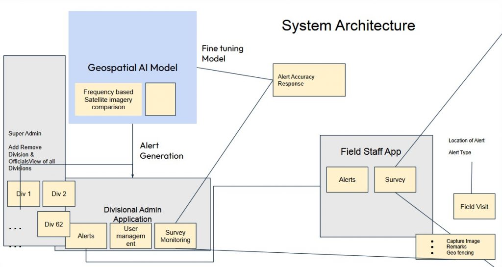
The system developed by Mr Rathore is a cloud-based platform that leverages Google’s satellite imagery database and is fully automated. New satellite images are updated every 2 to 3 days. Whenever fresh imagery arrives, the system automatically compares it with the previous image by calculating the difference between the two – essentially detecting any changes in the forest’s pixels over that period.
The system can identify even the slightest disturbances – detecting changes as small as 10×10 meters within forested areas. Whether it’s unauthorized farming, construction, or land-use shifts, the AI immediately flags the activity and sends alerts to forest officers. These alerts trigger rapid deployment of beat guards to the exact location for ground verification, allowing forest authorities to respond quickly and effectively to prevent illegal actions.”
He said, “This cloud-based system seamlessly integrates satellite imagery, machine learning algorithms, and real-time field feedback to monitor forest areas with unprecedented accuracy and efficiency.”
EXPLAINING THE MODEL: HOW IT WORKS
To explain this process, IFS Rathore gives a simple example – “If today is the 1st of the month and we receive an image today, the next image will arrive on the 3rd, given the 2-day frequency. As soon as the new image is received on the 3rd, the system runs its code automatically to subtract the pixels of the image from the 1st from the pixels of the image on the 3rd.” These satellite images are raster files, and by subtracting them, the system highlights areas where changes – whether positive or negative – have occurred.
While this may sound technical and abstract, he explains that the system then uses a method called kernel size 2 connectivity to connect adjacent pixels that have changed, forming a loop or cluster. This creates a defined area where change is suspected, even if not every pixel in that area shows change individually. Essentially, the system identifies the zone likely affected by deforestation or other disturbances.
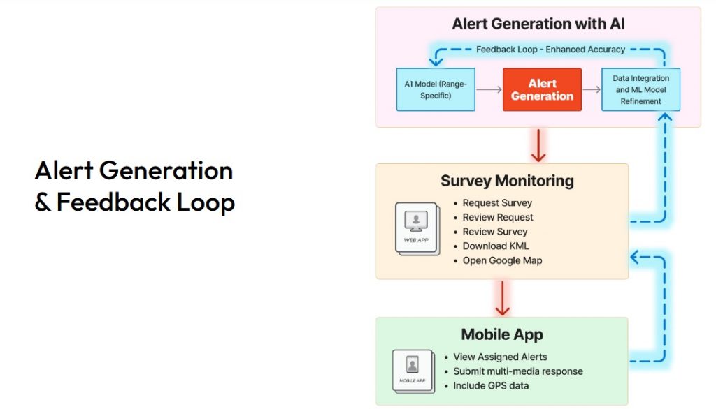
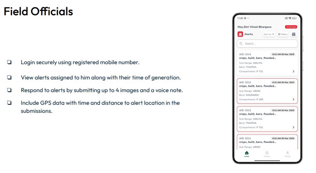
Remarkably, the entire analysis takes only about two minutes to process after receiving the new imagery. Once the analysis is complete, the system immediately sends an alert to the mobile phones of forest officials, from the DFO to the beat guards. This is done via a specially developed app.
Upon receiving an alert, forest officials visit the detected area and record evidence by clicking photos within the exact polygon of the detected change. This photo verification confirms that the forest staff physically inspected the location, ensuring accountability and real-time monitoring of forest protection activities.
DATA-DRIVEN AI FEEDBACK
All this data – images, alerts, and verification photos – is uploaded to a central dashboard monitored by the DFO. The DFO reviews the reports and provides feedback by marking activities as true or false, indicating whether the alert corresponds to actual deforestation or false positives. These feedbacks are stored in the system as binary values (1s and 0s), which feed into the AI model to continuously improve its accuracy over time.
Thanks to this loop of data collection, verification, and AI refinement, the system becomes smarter and more precise with each use, helping ensure that no deforestation activity goes unnoticed.
“Drawing from my field experience, I created a dynamic AI model to improve accuracy and built the alert system using Python. I was responsible for designing the entire core framework, tailoring it specifically for tablet use by forest officials,” he shared.
The current system promotes staff accountability through geo-tagged photo uploads from designated alert zones. In Phase 2, the focus shifts to full automation – minimizing manual intervention and making forest monitoring faster and more efficient.
WIDESPREAD BENEFITS: MONITORING, MANAGEMENT, AND MINDSET
Highlighting the system’s impact, Mr Rathore emphasized that it offers several key advantages, both strategic and operational.
“One of the most important benefits,” he said, “is the psychological warfare it creates. Those involved in illegal activities now know they are being monitored in real-time. This constant surveillance acts as a strong deterrent and keeps wrongdoers on edge.”
In addition to this psychological edge, the system allows authorities to track the movement and activities of forest staff effectively. “We can verify whether they are visiting the areas flagged by the system, which ensures accountability and enhances on-ground enforcement.”
The system is designed with eight classification categories, allowing it to monitor a wide range of forest-related issues.
The model is also highly versatile, capable of monitoring a wide range of forest-related activities such as illegal tree felling, cultivation on forest land, crop encroachment, intrusion into sensitive ecological zones, over-exploitation of resources like water and grasses, and encroachments in protected areas. This broad monitoring capacity makes it a powerful tool for forest management.
Importantly, the system can be customized to prioritize different types of activities based on local challenges. For example, in Guna – where encroachment is a major concern – the system is set to focus more on detecting encroachment than crop cultivation. Conversely, in tiger reserves, it can be adjusted to prioritize water bodies, grasslands, or wildlife corridors.
With this system in place, forest authorities are not only able to respond to threats more efficiently, but they are also staying one step ahead – curbing illegal activities through both surveillance and psychological presence. “This gives us a clear advantage,” Mr Rathore concluded.
TRIGGER FOR SOLUTION
According to the Forest Survey of India’s 2023 report, Madhya Pradesh holds the largest forest and tree cover in the country – spanning 85,724 square kilometers – but also recorded the highest loss of forest land, with around 612.41 square kilometers affected.
The turning point came around Diwali in 2024, when a land dispute between two communities escalated into violence. The conflict, which claimed the life of a community leader and resulted in incidents of arson, prompted Mr Rathore to begin developing an AI-based solution. Witnessing the consequences of delayed intervention, he realized the urgent need for a system that could detect and prevent such encroachments before they spiral out of control.
FASTER THAN KARNATAKA MODEL
To design his system, Mr Rathore studied Karnataka’s alert-based forest monitoring model. “Their system sends alerts every 21 days, while ours aims for every 2–3 days for quicker response,” he said.
“We’re also building a pre-monsoon database to train the model. Once it hits 99% accuracy, it will predict illegal activities, aid resource management, and improve budget and manpower planning across forest divisions.”
The Forest Department plans to deploy drones to replace some manual tasks, boosting efficiency and coverage. Mr Rathore emphasized that adding year-wise data is key to building a strong time-series model, reducing seasonal errors and enhancing overall accuracy.