Rajasthan: In a striking demonstration of mobility and combat readiness, the Indian Air Force (IAF) carried out emergency landings and take-offs from a highway segment near Barmer in Rajasthan as part of the ongoing exercise Maha Gajraj. By converting a stretch of the Bharatmala highway into an operational runway, the IAF signalled its ability to operate from unconventional locations close to the India-Pakistan border.
Background of the IAF Maha Gajraj Exercise
Bordering Pakistan, Rajasthan’s Barmer-Jalore region has emerged as a strategic arena for India’s defence drills. Under the tri-services exercise framework of Trishul, the IAF’s Maha Gajraj component emphasised high-intensity air operations from forward strips.
On this occasion, Highway 925 (near Gandhav/Bakhasar) was repurposed into a 3-km long, 33-metre wide airstrip for fighter and transport aircraft.
About the Officer & Units Involved in IAF Maha Gajraj Exercise
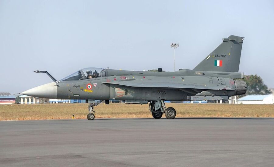
While full identification of the commanding officer remains undisclosed, Wing Commander Devendra Pandey (IAF) was quoted explaining that the exercise aimed to assess the viability of such improvised air-strips in real war-like scenarios. The drill included transport aircraft C‑295, and fighter jets such as the Sukhoi‑30 MKI and Jaguar (fighter‑jet).
Importance of the IAF Maha Gajraj Exercise
Strategic flexibility: Operating from highways means the IAF can bypass damaged or compromised airbases in conflict zones, thereby enhancing resilience.
Border deterrence: Conducting such operations close to the Pakistan border sends a clear message regarding India’s readiness and deterrence posture.
Operational preparedness: The drill tested rapid turnaround, landing-taxi-takeoff cycles under constrained conditions, sharpening combat launch capability.
Infrastructure utilisation: Leveraging existing road networks as runway strips minimises dependency on fixed airbases, advantageous in asymmetric warfare.
Key Challenges to Watch
Safety and logistics: Converting a highway into a runway requires meticulous planning—road closures, civilian traffic management, runway marking, and clearance of obstacles.
Aircraft limitations: Fighter jets and transport aircraft landingon un-designed surfaces demand precise pilot control and adaptation to non-standard runway characteristics.
Rapid conversion: The time and resources required to transform a public highway into a functional airstrip remain operationally challenging.
Border proximity risks: Operating so close to the international boundary could expose assets to surveillance or reactive enemy measures—thus the exercise carries heightened risk and stakes.
Implications of IAF Maha Gajraj Exercise
For India’s defence architecture: Demonstrates a shift toward more agile air operations, where mobility and dispersion become core to defence planning.
For adversaries: Signals that traditional airbase-centric planning may no longer guarantee safe sanctuary near conflict zones.
For infrastructure developers: Highlights the multi-role potential of highways under the Bharatmala Pariyojana scheme, not just for traffic, but for defence use.
For civil-military synergy: Shows increasing integration between defence operations and civil infrastructure management—road closures, coordination with local administration, security deployment.
Way Forward
Institutionalise highway-airstrip doctrine: The IAF should develop standard operating procedures for converting roadways into runways, including maintenance, marking, and rapid deployment kits.
Expand terrain variety: Similar drills could be conducted across varied geographies—mountainous terrain, coastal highways—to broaden adaptability.
Infrastructure dual-use design: Future highway planning under Bharat Mala can incorporate defence-ready design specifications (length, strength, clearance zones) to facilitate faster conversion.
Joint tri-services drills: To maximise combat efficacy, further exercises involving the Army and Navy alongside the Air Force from mobile strips would enhance full spectrum operations.
Community & traffic management protocols: Since civilian traffic is affected, robust community communication, alternate routes and minimal disruption strategies should be finalised.