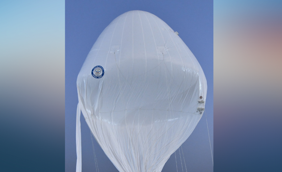
New Delhi: DRDO high altitude platform system (HAPS) has successfully completed a major flight test, marking an important achievement for the country’s indigenous aerospace and surveillance technology programs.
According to official information shared by DRDO, the long-endurance stratospheric aerial surveillance platform was designed and developed by the Aerial Delivery Research and Development Establishment (ADRDE), Agra. The successful test demonstrates India’s growing capabilities in near-space surveillance and monitoring technologies.
What Happened During The DRDO High Altitude Platform System Flight Test
The experimental flight reached an altitude of 21 kilometers above mean sea level (AMSL). After reaching the target altitude, the platform maintained a stable altitude of around 20 kilometers for more than 30 minutes while carrying useful instrumentation systems and payloads.
DRDO said that after completing the mission objectives, the platform was instructed to descend safely to the ground. The system was successfully recovered, and engineers analyzed the flight performance data collected during the mission.
Key Highlights Of The DRDO High Altitude Platform System Test
- Successfully developed by ADRDE, Agra.
- Reached 21 km altitude above mean sea level.
- Maintained 20 km altitude for over 30 minutes.
- Carried useful instrumentation payloads.
- Completed a controlled descent and recovery.
- Flight data was successfully collected and analyzed.
What Is A High Altitude Platform System
A High Altitude Platform System (HAPS) is an aerial platform that operates in the stratosphere, generally around 20 kilometers above Earth.
These systems are often described as a bridge between conventional aircraft and satellites because they can remain at high altitudes for long periods while providing surveillance, communication, intelligence gathering, and remote sensing capabilities. Unlike satellites, HAPS platforms can be deployed more flexibly and can focus on specific regions for extended durations.
Why Is DRDO High Altitude Platform System Test Important For India
The successful flight demonstrates India’s progress in developing indigenous technologies for persistent aerial surveillance.
Platforms operating at stratospheric altitudes can provide wide-area observation and monitoring, making them valuable for defense, border surveillance, disaster management, telecommunications, and environmental monitoring. The achievement also strengthens India’s efforts to reduce dependence on foreign technologies in the critical defence and aerospace sector.
Role Of ADRDE In The Project
The High Altitude Platform System was developed by ADRDE, a DRDO laboratory located in Agra. The organization has extensive experience in aerial delivery systems, aerostats, airships, parachutes, and related aerospace technologies. Over the years, ADRDE has contributed to several important indigenous defense projects.
Read also: Explained: How India’s National Aero Engine Test Complex Will Strengthen Defence and Aerospace Power
FAQs
HAPS is a long-endurance aerial platform that operates in the stratosphere at very high altitudes. It can be used for surveillance, communications, intelligence gathering, and remote sensing missions.
The platform successfully reached 21 kilometers above mean sea level and maintained an altitude of 20 kilometers for more than 30 minutes during the flight test.
The system was designed and developed by the Aerial Delivery Research and Development Establishment (ADRDE), Agra, a DRDO laboratory specializing in aerial delivery and airborne systems.