At the confluence of geography, geopolitics, and geoeconomics lies one of India’s most ambitious infrastructure ambitions: the Great Nicobar Island (GNI) Development Project. Conceived in 2021 and valued at nearly USD 10 billion, the project aims to transform a remote, ecologically rich island into a dual-use maritime hub and forward military outpost. The project, however, has also triggered sharp criticism over its environmental and humanitarian costs. Experts warn that large-scale deforestation, pressure on fragile ecosystems, and the potential threat to the survival of the indigenous Shompen tribe could irreversibly alter one of India’s most sensitive island landscapes.
To understand its full implications, one must move beyond the visible architecture of development and examine the deeper logic at play, the intersection of India’s maritime rise, China’s vulnerabilities, and growing ecological concerns.
Geography as Strategy: The Natural Aircraft Carrier that India has Finally Boarded
TheGreat Nicobar’s value is inherited in India’s strategic culture. Positioned at the southernmost tip of the Andaman and Nicobar archipelago, the island overlooks the Six Degree Channel, a principal maritime gateway feeding into the Strait of Malacca- one of the most critical chokepoints in global trade.
This geography places India at the threshold of a corridor through which flows a substantial share of global commerce and energy. For China, in particular, this passage is an economic lifeline, yet also a strategic Achilles’ heel. The island’s proximity to key nodes such as Singapore, Colombo, and Port Klang enhances its significance, effectively turning it into a vantage point capable of observing, and potentially shaping maritime traffic.
For decades, this advantage remained unexplored. The Great Nicobar Project signals a doctrinal shift: from geographic fortune to geographic strategy. It is India’s attempt to convert positional advantage into operational leverage.
The Architecture of Transformation: Building a Dual-Use Maritime Complex
At the heart of the project lies the proposed transshipment port at Galathea Bay, endowed with a natural draft of 18-20 metres, it would be sufficient to handle ultra-large container vessels that bypass most Indian ports today. The port aims to challenge entrenched hubs like Singapore and Colombo.
This ambition is not merely commercial. It is corrective. Nearly a quarter of India’s cargo is currently transshipped through foreign ports, representing both economic leakage and strategic vulnerability. The Galathea Bay terminal seeks to internalise this value while embedding India more deeply into global supply chains.
Complementing the port is a dual-use international airport, capable of supporting both civilian logistics and military deployment. Its significance lies in enabling rapid force projection, surveillance, and connectivity across the eastern Indian Ocean. Supporting infrastructure, including a 450 MVA power plant, reflects the intent to build not just a port, but a self-sustaining maritime-industrial ecosystem.
The planned township, envisioning a population expansion from roughly 8,000 to several hundred thousand, signals the project’s transformative scale. This is not incremental development; it is the creation of a new strategic-economic node.
The Malacca Dilemma: Structural Vulnerability of China Meets India’s Strategic Opportunity
The project’s geopolitical resonance becomes clearer when viewed through the lens of the “Malacca Dilemma,” a term popularised by former Chinese President Hu Jintao. It captures Beijing’s deep anxiety over its dependence on a narrow maritime corridor for energy and trade.
As of 2025, more than 80% of China’s oil imports, valued at approximately U.S.D 312 billion a year, pass through the Strait of Malacca, which is only 2.8 km wide at its narrowest point. Approximately U.S.D 3.5 trillion in global business, two-thirds of all Chinese marine traffic, travels through these waterways annually. The arithmetic is terrifying for Chinese strategic planners. The world’s second-largest economy, with the second-largest military, has threaded the needle of its entire industrial civilisation through a chokepoint narrower than many rivers.
By positioning itself near the northern approaches to Malacca, India does not merely observe the chokepoint, it acquires the capacity to influence it. From Beijing’s perspective, this is not a marginal shift but a structural complication with long-term consequences.
Militarisation of the Maritime Frontier: From Metaphor to Capability
The Andaman and Nicobar Islands have long been described as a “natural aircraft carrier.” The Great Nicobar Project operationalises this metaphor.
Planned expansions also include upgrades for P-8I maritime patrol aircraft and enhanced underwater surveillance. Great Nicobar already hosts INS Baaz, an operational naval airbase at Campbell Bay, overlooking the vital Six Degree Shipping Channel between Great Nicobar and Sumatra.
India has begun constructing a second airfield at Chingen village on Great Nicobar Island, near Galathea Bay and about 150 km northwest of Banda Aceh in Sumatra. This forms part of a broader military buildup, with naval air stations being upgraded to host P-8I Poseidon aircraft and fighter jets. At INS Utkrosh, new hangars, dispersal systems, a precision approach radar, and the Integrated Underwater Harbour Defence and Surveillance System were added in 2024. Communication network centres at INS Kohassa, INS Baaz, and INS Kardip further strengthen operational readiness across the island chain.
It is in this context that defence experts frame the project not as development, but as strategic necessity. Former IAF Chief R.K.S. Bhadauria has argued that the initiative is vital for expanding India’s “military footprint” in the Indo-Pacific, warning that opposition to it could inadvertently advantage China.
Similarly, Air Vice Marshal (Retd.) P.K. Srivastava underscores the chokepoint logic, noting that maritime bottlenecks, much like the Strait of Hormuz have become decisive instruments in modern geopolitics. In his assessment, the project will allow India to “better monitor and manage maritime movement in one of the world’s busiest trade corridors.”
Countering the “String of Pearls”: India’s Diamond Necklace
India’s evolving “Diamond Necklace” strategy is best understood as a geostrategic response to China’s “String of Pearls”, Beijing’s network of ports and dual-use facilities stretching from Gwadar to Hambantota and Kyaukphyu, designed to secure sea lines of communication while expanding strategic reach.
India has now begun to play the same game, and from a far more advantageous geographic position. Every Chinese spy ship in the Bay of Bengal, every PLAN submarine probing these waters, is now being watched from an island that will soon host advanced radar, patrol aircraft, and naval strike capability
Where China has sought access points along the Indian Ocean littoral, India is building a distributed arc of influence through partnerships, port development, logistics agreements, and forward military presence: from Duqm in Oman to Sabang in Indonesia and Assumption Island in Seychelles.
In this architecture, the Great Nicobar Island project emerges as a pivotal eastern anchor. Great Nicobar, describe as “strategic fulcrum in the Indian Ocean,” complements India’s wider maritime outreach by adding a hard-power edge to a largely partnership-driven strategy, effectively tightening the strategic envelope around key chokepoints and reinforcing India’s ability to monitor, deter, and, if necessary, influence traffic through one of the world’s most critical trade corridors.
India’s response has since matured into a more coherent and strategically aligned framework. Initiatives such as Project Mausam, the operationalisation of Vizhinjam Port, and the articulation of the India-Middle East-Europe-Economic Corridor (IMEEC) collectively signal a shift toward networked connectivity and strategically anchored infrastructure, designed not merely to facilitate trade, but to shape regional influence and secure India’s position within evolving global supply chains.
Economic Statecraft: Competing with Singapore
The economic logic of the project is as important as its strategic rationale. The Great Nicobar Island Project involves a transshipment port, an international airport, township development, and a 450 MVA gas and solar based power plant. The transshipment port at Galathea Bay aims to handle 4 million TEUs (Twenty-foot Equivalent Unit) by 2028 and 16 million TEUs by 2058, through this hub, India seeks to capture value currently accruing to established players like Singapore.
This is an ambitious proposition. Singapore’s dominance rests not only on geography but on institutional efficiency, regulatory predictability, and deep integration into global shipping networks. Yet Great Nicobar offers structural advantages, proximity to major shipping lanes and natural depth, that could, if leveraged effectively, attract a share of this traffic.
The experience of Vizhinjam, which has already begun diverting cargo flows, suggests that such shifts are possible. However, success will hinge on more than infrastructure. It will require policy coherence, logistical integration, and sustained commercial credibility.
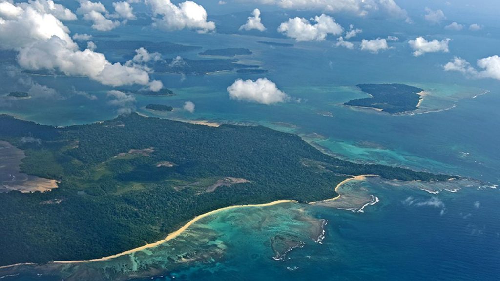
Ecological Fragility and Environmental Costs
The promise of economic and strategic gain is slightly shadowed by significant environmental concerns. Great Nicobar is one of India’s most ecologically sensitive regions, home to dense tropical rainforests, unique biodiversity, and fragile coastal ecosystems.
The project entails the diversion of approximately 130 square kilometres of forest land and the felling of nearly one million trees. This raises serious questions about habitat loss, carbon emissions, and long-term ecological sustainability. Species such as the leatherback sea turtle, which relies on the island’s beaches for nesting, face disruption.
Proposed mitigation measures, including compensatory afforestation and wildlife translocation, have been met with skepticism from environmentalists, who argue that such interventions cannot replicate the complexity of old-growth ecosystems.
Seismic Uncertainty and Disaster Risk
Adding to the environmental concerns is the island’s geological vulnerability. Great Nicobar lies in Seismic Zone V, the highest risk category in India, and is situated near a major tectonic boundary.
A study by Indian Institute of Technology Kanpur mentions the inherent risks, noting that the island chain falls within a high-intensity seismic zone that was directly impacted by the 2004 Indian Ocean tsunami. The report estimates a “return period” of approximately 420-750 years for mega-earthquakes (magnitude 9 or above) and 80-120 years for large-magnitude events exceeding 7.5, indicating a structurally elevated seismic vulnerability.
Thus, the prospect of building ports, airports, and urban settlements in an area prone to earthquakes and tsunamis raises complex questions about resilience, safety, and long-term viability.
Indigenous Communities and the Ethics of Development
At the human level, the stakes are existential. The Shompen, a particularly vulnerable tribal group of fewer than 300 individuals who live in near-complete isolation within the project area, stand to be most severely affected. Their language has not been fully deciphered.
Anthropologists and rights groups have long cautioned that any large-scale development in their territory risks the group’s cultural and physical survival.
In 2025-26, the Nicobarese Tribal Council alleged that the administration falsely certified community consent for the project. Critics further argue that the high-powered committee model imposed by the government to govern tribal affairs effectively undermines the democratic Gram Sabha powers that tribal councils are entitled to under the Forest Rights Act.
The island’s current population is projected to increase more than 80-fold once the project is fully operational. That scale of demographic transformation, critics say, would place irreversible pressure on resources and almost certainly erase the cultural fabric of indigenous communities that have inhabited these islands for centuries.
Government’s position and legal backing
The government maintains that the project has received environmental clearance subject to 42 strict compliance conditions covering biodiversity, pollution, marine ecology, and disaster management. Three independent monitoring committees have been established to oversee pollution control, biodiversity protection, and tribal welfare.
In February 2026, the National Green Tribunal declined to interfere with the clearance, citing what it described as adequate safeguards and the project’s strategic importance. Legal challenges, however, continue in the Calcutta High Court.
Conclusion: Infrastructure as Geopolitics
The Great Nicobar project now sits at the intersection of India’s most pressing strategic imperatives and its most difficult domestic obligations.
For a government that has made maritime power projection a central plank of its foreign policy, abandoning the project is barely a political option. For the Shompen, for the leatherback turtle, and for the, the calculation looks very different.
For India, it represents an attempt to translate geography into influence, to move from the margins of maritime strategy to its centre. For China, it sharpens an already acute vulnerability. For the Indo-Pacific, it signals a future in which control over infrastructure equates to control over outcomes.
Whether the project ultimately succeeds will depend not only on execution, but on India’s ability to balance ambition with responsibility. What is certain, however, is that once built, Great Nicobar will not simply exist within the strategic landscape it will help define it.
Read Also: Securing Inviolate Area For The Wild – A Mirage, Or A Thwarted Dream?