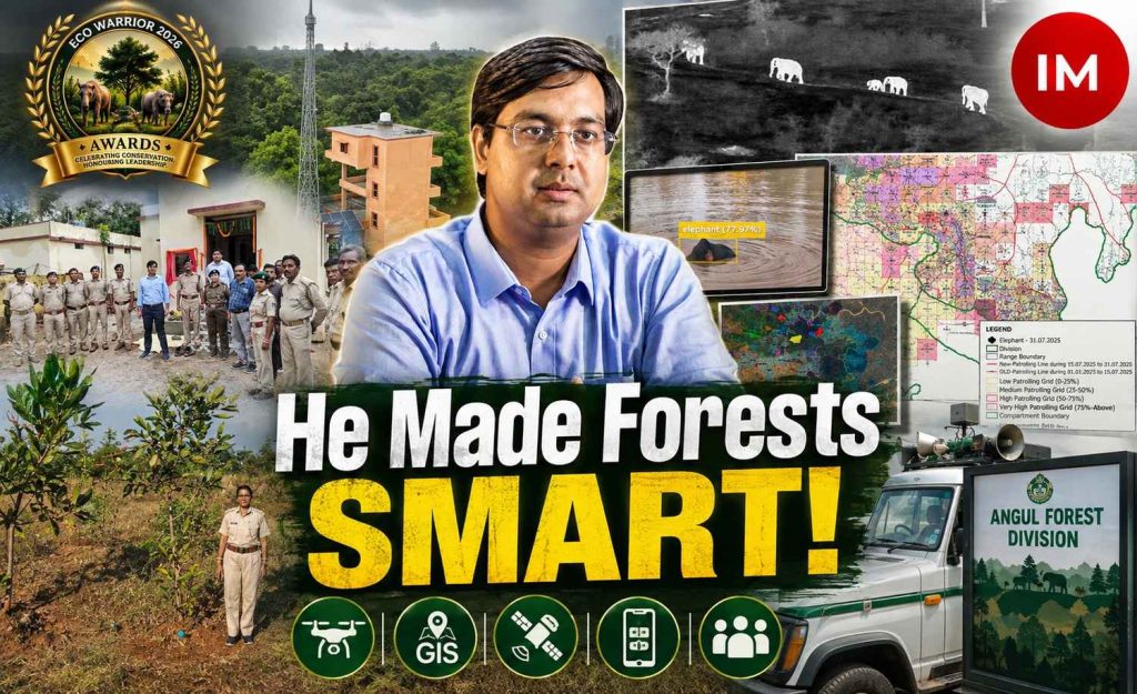
Forests are living, complex systems where every decision – from preventing a fire to protecting an elephant corridor or restoring a degraded habitat – can have consequences far beyond the immediate landscape. In such a demanding environment, technology is emerging not as a replacement for field experience, but as a powerful tool to make conservation more precise, responsive and effective. In Odisha, Nitish Kumar, IFS, is demonstrating how this convergence of technology, science and grassroots administration can reshape forest governance.
A 2014-batch Indian Forest Service officer (IFS) and currently DFO, Angul Forest Division, Mr Kumar has brought artificial intelligence, drones, GIS, remote sensing, satellite analytics and digital platforms into the everyday functioning of forest management. His interventions have addressed some of the most difficult challenges facing forests today – forest fires, wildlife protection, human-elephant conflict, habitat restoration and public service delivery – while producing measurable results on the ground.
Speaking to Indian Masterminds, IFS Kumar explained that the foundation of his approach is simple: better data can lead to better decisions, particularly when that data reaches the people working directly in the forest.
How It Started: Bringing Data to the Ground
Managing a forest involves dealing with multiple variables simultaneously, from terrain and drainage patterns to vegetation, wildlife movement and human activity. Kumar believes that technology can help frontline personnel understand these variables and make informed decisions.
“The point is that our forest is a very complex area. We have to do a lot of work in it. Suppose we have to do soil moisture management, we have to decide where the site is, where we have to intervene. For that we have to do a lot of data analysis,” he said.
Read Also: From Tiger Rescues to 12 Wetlands: How IFS Akash Deep Badhawan Is Transforming Conservation in UP
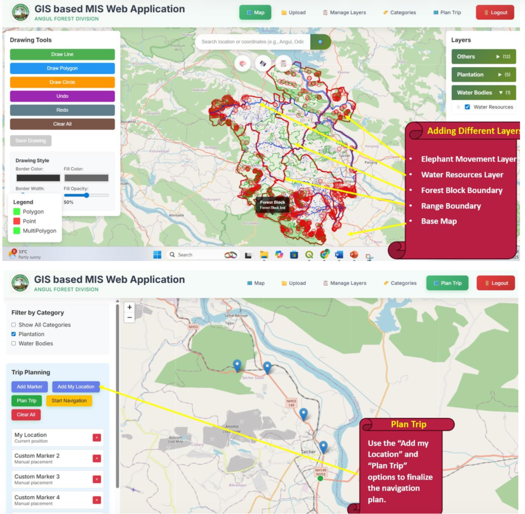
This thinking led to the development of a GIS-based Management Information System (MIS) Portal for Angul Forest Division. The platform brings together information on elephant movement, wildlife depredation, soil and moisture conservation waterbodies, plantations and other forest assets.
The portal allows different GIS layers to be superimposed and analysed according to the requirement of field staff. Importantly, access extends down to the Forest Guard or beat level.
“We have made a GIS-based portal, in which all the data is fed. The people working at the grassroots level can do data analysis,” Mr Kumar explained.
The system is designed to be accessible even to users without specialised GIS training. With mobile access and basic internet connectivity, frontline staff working in remote locations can access information that earlier remained largely confined to division offices or GIS cells.

From GIS Maps to Better Field Decisions
The GIS system is not merely a digital repository. Its purpose is to support decisions before interventions are undertaken on the ground.
“Mainly, there is a GIS feature, in which there will be many layers, so as per their requirement, they will choose the layer, and according to that, by doing analysis, the decision-making at the field level is supported,” Mr Kumar said.
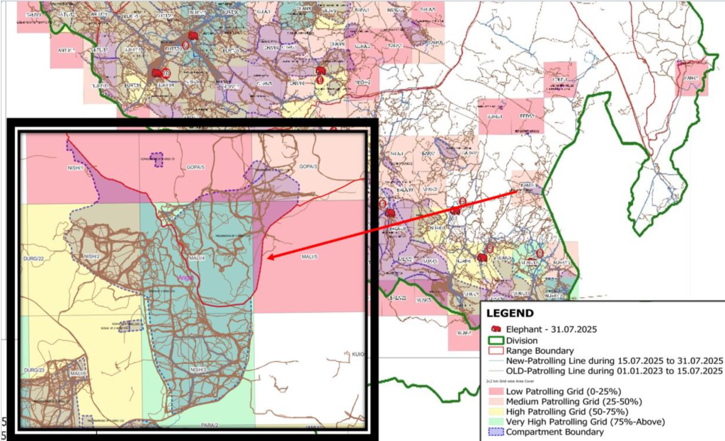
GIS and remote sensing have also been used to analyse forest patrol patterns and identify “grey areas” where coverage could be improved. This data-driven approach has helped strengthen foot patrolling across the Angul Forest Division.
The division has subsequently emerged as the top-ranking division in Odisha in terms of cumulative forest patrolling undertaken by the DFO, ACFs, Range Officers, Foresters, Forest Guards and patrolling squads. In May 2026 alone, the cumulative patrolling covered 32,816 km.
Fighting Forest Fires With Real-Time Intelligence
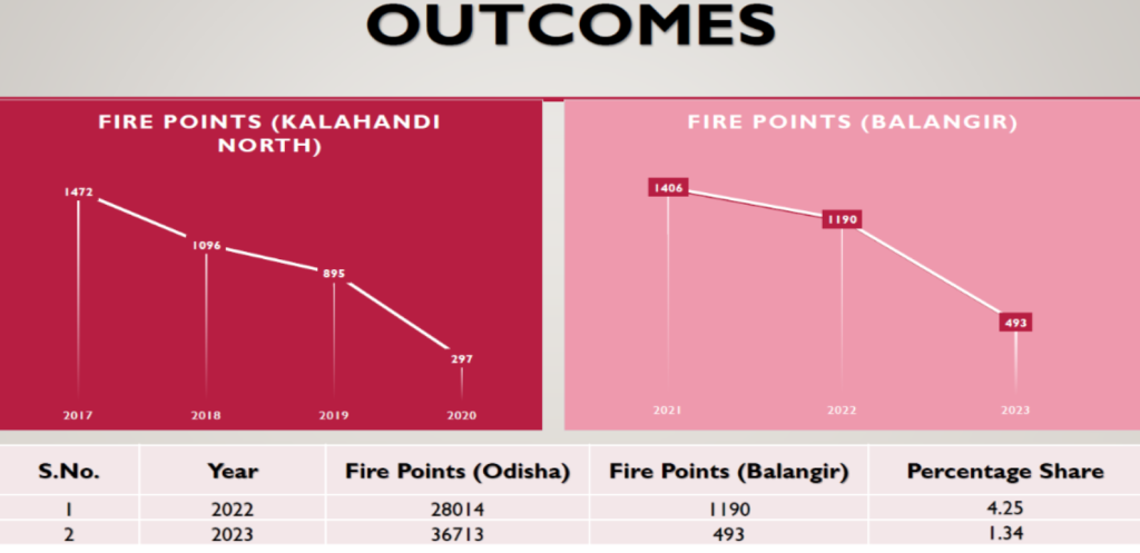
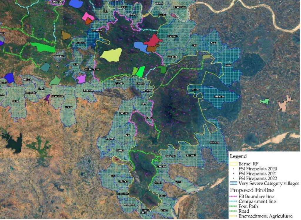
One of Kumar’s most significant interventions has been the Fire Control Rapid Response System, implemented across the Kalahandi North, Balangir and Angul Forest Divisions.
The system uses NASA’s Fire Information for Resource Management System (FIRMS) for real-time fire alerts. FIRMS draws data from five instruments, compared with three used for fire alerts by the Forest Survey of India, providing a wider stream of information for rapid response.
GIS technology was then used to map roads, nallahs, old fire lines, plantation fire lines, forest blocks and compartment boundaries. Natural features such as roads, footpaths and nallahs were converted into strategic fire lines after clearance, while additional fire lines were created based on GIS analysis and historical fire patterns.
The results have been striking. In Balangir, the division’s share of Odisha’s fire points fell from 4.25% to 1.34%.
In Angul, despite rapid industrialisation, expanding opencast mining and other anthropogenic pressures, forest-fire alerts fell from 738 in 2023 to 333 in 2026, while the affected area dropped dramatically from 157.1 hectares to 12.35 hectares.
Using AI to Watch Over Wildlife
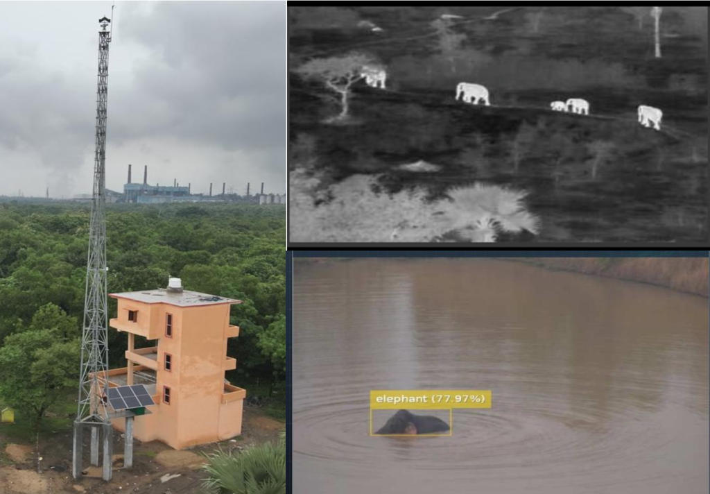
Technology has also become an important part of wildlife protection. Four AI-enabled e-Eye monitoring towers have been installed in key elephant movement areas – two in Jarapada Range, one in Talcher Range and one in Chhendipada Range.
Equipped with advanced sensors and automated 360-degree surveillance cameras, the towers continuously monitor movement. AI algorithms detect elephant presence and transmit alerts to the control room, allowing forest officials to respond quickly and warn vulnerable communities.
In 2026 so far, the system has recorded 51 elephant detection events.
The division has complemented these systems with thermal-imaging drones, ground tracking, early warning systems and speaker-mounted drones as part of a broader science-based strategy to mitigate human-elephant conflict.
Restoring Habitats Through Science
Technology-driven planning has also been extended to habitat restoration and soil and moisture conservation. Drone-based habitat modelling, GIS analysis and field-level assessments have supported planning worth more than ₹20 crore for soil and moisture conservation interventions.
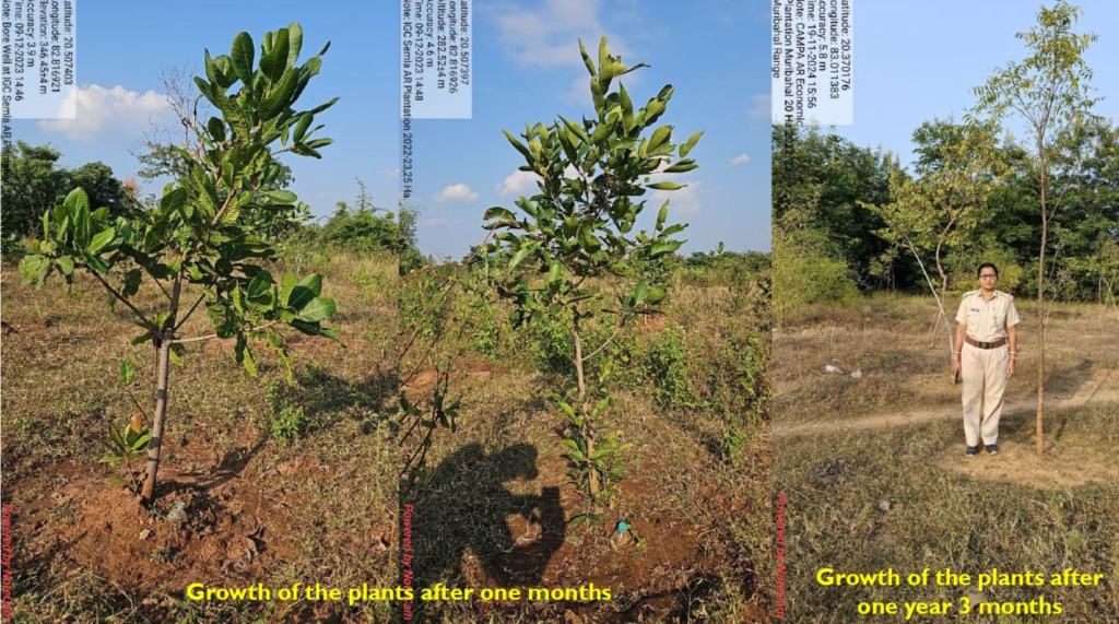
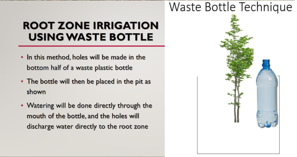
The division has also introduced root-zone irrigation, which delivers water directly to the root zone of plants. The objective is to make better use of limited water resources while improving plantation survival.
These restoration efforts are beginning to show visible ecological outcomes, with more than 70 elephants regularly sighted in restored landscapes, indicating improved habitat suitability and availability.
Making Forestry More Accessible to Citizens
Mr Kumar’s technology-driven approach does not stop with departmental systems. Citizen participation has been built into the model through digital platforms such as the Sabuja Angul mobile application and the official Angul Forest Division website.
Through the app, citizens can request seedlings and report issues such as illegal tree felling or wildlife-related activities. Complaints can be submitted through photographs, videos or messages and are transmitted to forest officials for action.
“The public also uses it. We need plant seedlings, so they also request through it, and if the public has to give a complaint, that there is illegal tree felling, or some wildlife hunting activities are taking place, then through video, photo, or message, they can send it to us,” he said.
The platform has been operational for about a year and has already begun changing the way people interact with the department.
Technology That Strengthens the Human Network
For IFS Kumar, perhaps the most important impact of digitisation is not the technology itself, but the confidence and capability it gives frontline personnel.
“Our staff have strengthened. Many of them are connected to us, they are giving complaints, so they also feel that there is an option – that for everything, we don’t have to go to the division office or the range office,” he said.
The system allows staff in remote areas to communicate with the department, access information, raise complaints and plan interventions without physically travelling to higher offices.
A Scalable Model for the Future
IFS Kumar has also documented his experience in the book “Applications of GIS & Drone Technology in Forestry & Wildlife,” recording the practical applications of these technologies in forest and wildlife management.
Taken together, his initiatives point towards a larger transformation in conservation administration—one where satellite data meets the field guard, AI alerts reach control rooms, GIS maps guide interventions, drones provide aerial intelligence and citizens become active participants in forest protection.
The significance of Mr Kumar’s work lies not simply in adopting sophisticated technology, but in adapting it to real field problems. By connecting scientific information with frontline execution and citizen participation, he is demonstrating that technology can make forest governance not only smarter, but also more responsive, transparent and resilient.
His journey offers a compelling lesson for conservation: when innovation is rooted in ecological understanding and backed by determined field-level execution, technology can become a force multiplier for both forests and the people entrusted with protecting them.
Read Also: From Engineering Desks to the Uniform: The Inspiring Journeys of UPSC CAPF 2025’s Top 5 Toppers