In Jharkhand’s forested belt, where elephants have roamed freely for centuries, the delicate balance between man and wildlife is under strain. Expanding villages, shrinking forests, and changing land-use patterns have pushed elephants closer to human habitations, leading to tragic clashes. Crops are destroyed overnight, homes are damaged, and lives, both human and elephant, are lost.
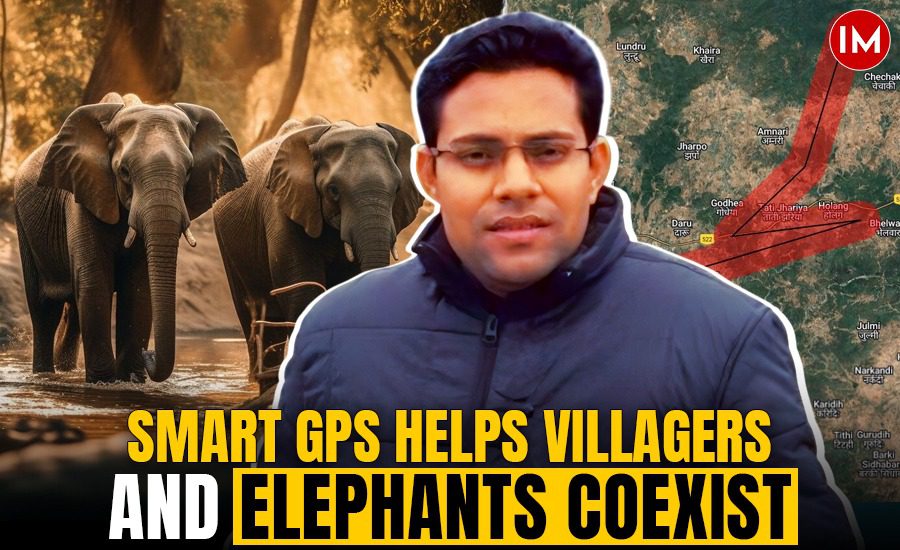
But in the Hazaribagh East Forest Division, something new is unfolding. A powerful mix of science, technology, and conservation is offering hope. At the heart of this innovation is IFS officer Vikash Kumar Ujjwal, 2014-batch, Jharkhand cadre, currently serving as Divisional Forest Officer (DFO), Hazaribagh (East).
“Human-elephant conflict is not just a conservation issue; it is a social problem. If we want to save elephants, we must first make sure people are safe,” he shared in an exclusive conversation with Indian Masterminds.
A DIGITAL STEP INTO THE ELEPHANT’S MIND
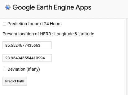
To manage this conflict, Ujjwal and his team have turned to technology: Elephant GPS, a web-based application built on Google Earth Engine. Unlike conventional methods that rely only on patrolling and local alerts, this innovation attempts to predict the elephant’s path, almost as if stepping into the animal’s mind before it makes its next move.
The app draws on nearly two decades of data, using legacy records of elephant movement and conflict history from 2004 to 2025. This historical knowledge is then layered with live environmental inputs to make its predictions more accurate. It factors in the availability of forage per hectare around the elephant’s current location, the presence of water sources in the landscape, and the topography, including natural passes and hill gaps.
It also considers natural barriers such as rivers and ridges, as well as seasonal preferences; for instance, elephants tend to favor southern-facing slopes in winter and northern-facing ones in summer. The algorithm further takes into account whether it is a large herd or a solitary elephant, the least resistance paths that elephants are likely to choose, and human habitations that may fall within their route. Together, these variables help the app simulate the decision-making process of elephants and predict their movement with remarkable accuracy.
“The idea was simple. If elephants move based on memory, food, and terrain, why can’t we simulate that movement through an algorithm? If the data is accurate, the prediction will be close to reality,” explains Ujjwal.
HOW THE APP WORKS
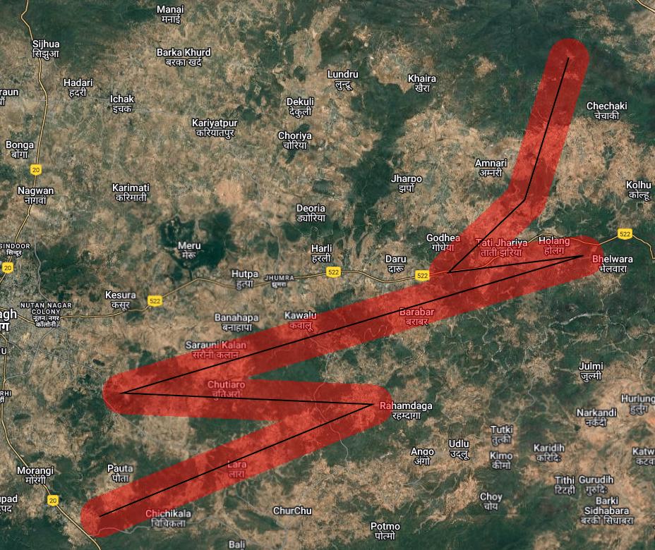
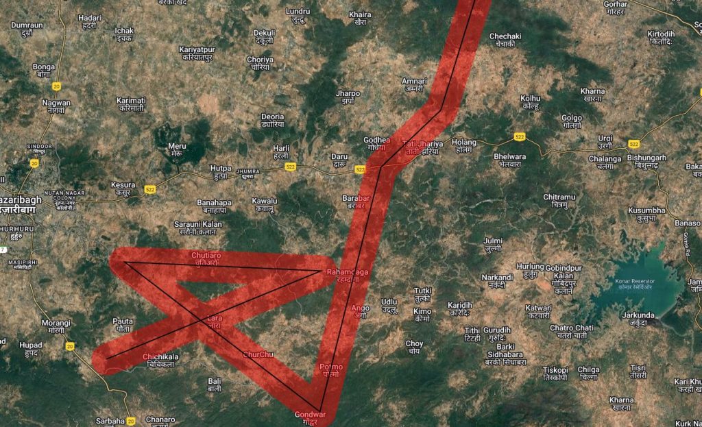
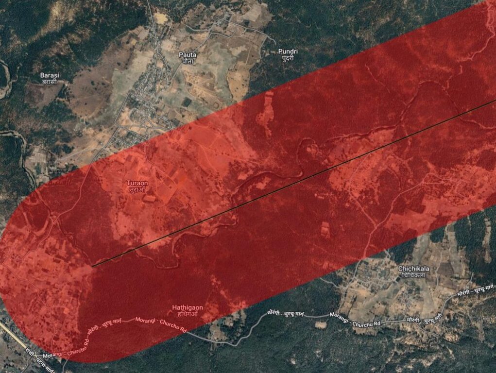
The Elephant GPS App accepts real-time input: the GPS coordinates of the last sighted elephant. With a single click on Predict Path, the app generates:
- A mean migration path (black line)
- Potential conflict zones (red areas) where herds are most likely to deviate
The output is displayed instantly on mobile or desktop screens, making it accessible to frontline staff on the ground.
In trials, the system has achieved nearly 80% accuracy, a breakthrough for an issue as unpredictable as elephant movement. Quick Response Teams (QRTs) are now better equipped: villagers are alerted in advance, patrol teams are deployed strategically, and elephants are guided safely through corridors.
“It gives us a clue about the herd’s position even at night, when visibility is low and chances of conflict are high,” shares Ujjwal. “That small head start makes a huge difference in saving lives.”
A PILOT THAT IS SAVING LIVES
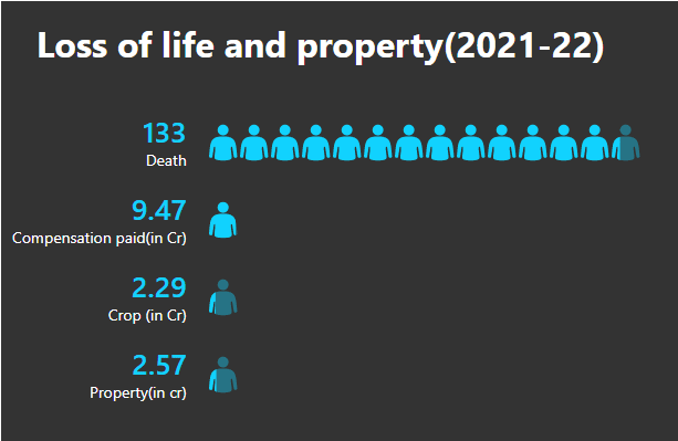
Over the last six months, the app has been piloted in Daru, Tatijharia, and Bagodar ranges of Hazaribagh East. Early results are striking. Human deaths have dropped, crop damage has reduced significantly, and property losses are fewer
The system doesn’t just provide predictions. It is designed with machine learning features. Every new GPS entry is fed back into the algorithm, making it smarter with time. In effect, the more elephants move, the more the app learns.
BEYOND PREDICTION
The app’s utility goes far beyond simply mapping elephant routes. It actively supports preventive strategies that help reduce the chances of conflict. For instance, it alerts forest staff to warn villagers about securing local liquor brewing areas, which often attract elephants. It also suggests temporarily closing down risky roads to avoid sudden encounters and, in more serious cases, evacuating vulnerable settlements in advance. Additionally, it helps in strategically positioning QRTs at key points, enabling them to divert or guide elephant herds safely away from human habitation.
“Since elephants are always on the move, no static solution can ever work. We need tools that adapt as the elephants adapt,” he shared with Indian Masterminds.
THE BIGGER PICTURE
Jharkhand is one of India’s states most severely affected by human-elephant conflict, with herds frequently crossing between fragmented habitats. Tools like Elephant GPS are not just local solutions but hold the potential for replication across elephant corridors in India.
Google Earth Engine also provides broader conservation benefits. It can map elephant habitats, assess vegetation quality, and identify critical corridors for protection. By processing massive datasets of satellite imagery, the platform offers forest managers insights that were once impossible to gather in real time.
LOOKING AHEAD
For now, the Elephant GPS remains a division-level tool, but Ujjwal believes its impact could be far-reaching. “Every forest division dealing with elephants can customize this app to their herds’ behavior,” he suggests. “If applied tactfully, it can change the way we manage this conflict across the country.”
A FUTURE WHERE BOTH CAN THRIVE
As villages and elephants continue to share space, the challenges will remain. But with tools like Elephant GPS, the chances of coexistence grow stronger. By combining traditional fieldwork with cutting-edge geospatial technology, officers like Vikash Ujjwal are proving that conservation in the 21st century is as much about algorithms as it is about empathy.
In the forests of Hazaribagh, technology is walking alongside giants and offering them and the people who live beside them, a safer future.